Complete Health Indicator Report of Utah Population Characteristics: Household Structure
Definition
Percentage of households by family type and presence of children.Numerator
Number of households in each family type and presence of children group.Denominator
Total number of households.Why Is This Important?
The number of parents living with a child helps to determine the human and economic resources available to that child. Children who live with one parent are more likely to live in poverty than are children who grow up in households with two adults. Single parents also face specific challenges including lack of leisure time, increased need for child care, and stressed financial resources.How Are We Doing?
Non-family households (either a householder living alone or with other, unrelated, persons) constituted less than a quarter (24.8%) of Utah households in the 2010 decennial census; the 2022 American Community Survey (ACS 1-year Table S1101) estimate was 26.5%. In 2010, of all Utah households, 7.8% were single householders with children; the 2022 ACS estimate was 4.9% (ACS 1-year Table CP02).How Do We Compare With the U.S.?
In 2000, 63.2% of Utah households included a married couple, either with or without children; the 2022 ACS 1-year Table CP02 now estimates this proportion to be 59.5%. In 2000, the U.S. estimate was 51.7%; by 2022 this had fallen to 46.9%. When we examine married couple households in Utah we see that in 2000, 55.4% of these households had children under 18. By 2022, this percentage had fallen to 27.9%. The estimate for this type of household in the U.S. was 45.5% in 2000, and has since fallen to 17.7% according to 2022 ACS table CP02 1-year estimates.Related Indicators
Related Relevant Population Characteristics Indicators:
Related Health Care System Factors Indicators:
Graphical Data Views
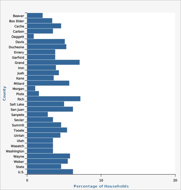
Percentage of Households with Children Under Age 18 Headed by a Single Female (no partner present) by County, Utah, 2018-2022 ACS

| County | Percentage of Households | Lower Limit | Upper Limit | |||
|---|---|---|---|---|---|---|
Record Count: 31 | ||||||
| Beaver | 2.1% | 0.4% | 3.8% | |||
| Box Elder | 3.4% | 2.5% | 4.3% | |||
| Cache | 4.6% | 3.8% | 5.4% | |||
| Carbon | 3.5% | 2.4% | 4.6% | |||
| Daggett | 0.9% | 0.0% | 2.2% | |||
| Davis | 5.1% | 4.5% | 5.7% | |||
| Duchesne | 5.3% | 4.2% | 6.4% | |||
| Emery | 3.8% | 2.1% | 5.5% | |||
| Garfield | 3.8% | 1.3% | 6.3% | |||
| Grand | 7.1% | 4.0% | 10.2% | |||
| Iron | 3.9% | 2.8% | 5.0% | |||
| Juab | 4.3% | 2.6% | 6.0% | |||
| Kane | 3.6% | 1.1% | 6.1% | |||
| Millard | 5.7% | 3.8% | 7.6% | |||
| Morgan | 1.1% | 0.1% | 2.1% | |||
| Piute | 1.6% | 0.0% | 4.1% | |||
| Rich | 7.2% | 2.2% | 12.2% | |||
| Salt Lake | 5.0% | 4.7% | 5.3% | |||
| San Juan | 6.2% | 4.1% | 8.3% | |||
| Sanpete | 2.8% | 1.9% | 3.7% | |||
| Sevier | 3.5% | 2.1% | 4.9% | |||
| Summit | 4.6% | 3.6% | 5.6% | |||
| Tooele | 5.4% | 3.9% | 6.9% | |||
| Uintah | 4.5% | 3.0% | 6.0% | |||
| Utah | 3.5% | 3.2% | 3.8% | |||
| Wasatch | 3.5% | 2.2% | 4.8% | |||
| Washington | 3.5% | 2.7% | 4.3% | |||
| Wayne | 5.8% | 1.1% | 10.5% | |||
| Weber | 5.5% | 5.0% | 6.0% | |||
| State | 4.6% | 4.4% | 4.8% | |||
| U.S. | 6.2% | |||||
Data Notes
The confidence intervals are 90%.Data Sources
- U.S. Bureau of the Census
- American Community Survey
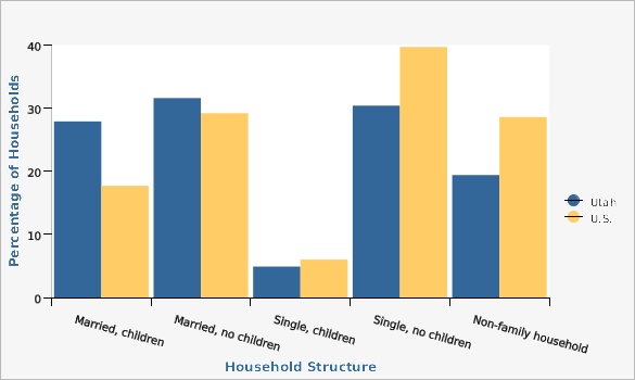
Percentage of Households by Family Type and Presence of Children, Utah and U.S., ACS 2022

| Utah vs. U.S. | Household Structure | Percentage of Households | ||||
|---|---|---|---|---|---|---|
Record Count: 10 | ||||||
| Utah | Married, children | 27.9% | ||||
| Utah | Married, no children | 31.6% | ||||
| Utah | Single, children | 4.9% | ||||
| Utah | Single, no children | 30.4% | ||||
| Utah | Non-family household | 19.4% | ||||
| U.S. | Married, children | 17.7% | ||||
| U.S. | Married, no children | 29.2% | ||||
| U.S. | Single, children | 6.0% | ||||
| U.S. | Single, no children | 39.7% | ||||
| U.S. | Non-family household | 28.6% | ||||
Data Notes
The data are from the American Community Survey Table CP02 1-year estimates.[[br]] Non-family household: a householder living alone or with non-relatives only.Data Sources
- U.S. Bureau of the Census
- American Community Survey
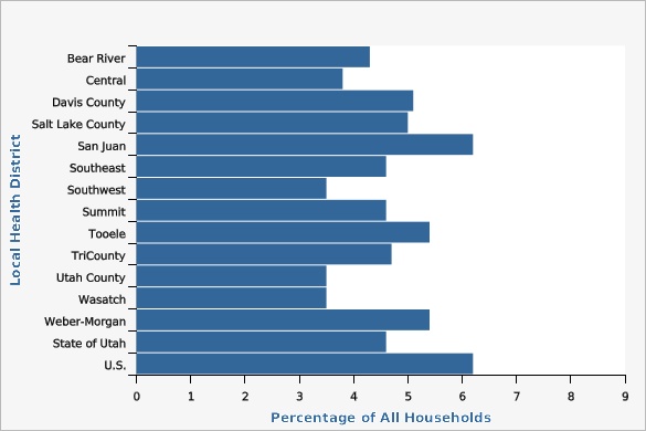
Percentage of Households with Children Under Age 18 Headed by a Single Female (no partner present) by Local Health District, Utah, 2018-2022 ACS

| Local Health District | Percentage of All Households | Lower Limit | Upper Limit | |||
|---|---|---|---|---|---|---|
Record Count: 15 | ||||||
| Bear River | 4.3% | 3.7% | 4.9% | |||
| Central | 3.8% | 3.1% | 4.5% | |||
| Davis County | 5.1% | 4.5% | 5.7% | |||
| Salt Lake County | 5.0% | 4.7% | 5.3% | |||
| San Juan | 6.2% | 4.1% | 8.3% | |||
| Southeast | 4.6% | 3.5% | 5.7% | |||
| Southwest | 3.5% | 2.9% | 4.1% | |||
| Summit | 4.6% | 3.6% | 5.6% | |||
| Tooele | 5.4% | 3.9% | 6.9% | |||
| TriCounty | 4.7% | 3.7% | 5.7% | |||
| Utah County | 3.5% | 3.2% | 3.8% | |||
| Wasatch | 3.5% | 2.2% | 4.8% | |||
| Weber-Morgan | 5.4% | 4.9% | 5.9% | |||
| State of Utah | 4.6% | 4.4% | 4.8% | |||
| U.S. | 6.2% | |||||
Data Notes
The confidence intervals are 90%.Data Sources
- U.S. Bureau of the Census
- American Community Survey
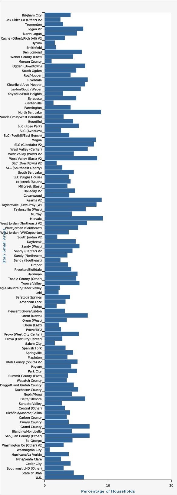
Percentage of Households with Children Under Age 18 Headed by a Single Female (no partner present) by Utah Small Area, 2018-2022 ACS

| Utah Small Areas | Percentage of Households | Lower Limit | Upper Limit | Note | ||
|---|---|---|---|---|---|---|
Record Count: 104 | ||||||
| Brigham City | 4.1% | 2.7% | 5.5% | |||
| Box Elder Co (Other) V2 | 2.5% | 1.0% | 4.0% | |||
| Tremonton | 2.9% | 1.3% | 4.5% | |||
| Logan V2 | 6.1% | 4.7% | 7.5% | |||
| North Logan | 5.1% | 3.3% | 6.9% | |||
| Cache (Other)/Rich (All) V2 | 3.2% | 1.9% | 4.5% | |||
| Hyrum | 1.6% | 0.3% | 2.9% | |||
| Smithfield | 1.8% | 0.4% | 3.2% | |||
| Ben Lomond | 5.9% | 4.7% | 7.1% | |||
| Weber County (East) | 4.5% | 3.2% | 5.8% | |||
| Morgan County | 1.1% | 0.1% | 2.1% | * | ||
| Ogden (Downtown) | 6.4% | 4.8% | 8.0% | |||
| South Ogden | 5.0% | 3.7% | 6.3% | |||
| Roy/Hooper | 4.1% | 3.0% | 5.2% | |||
| Riverdale | 6.8% | 4.9% | 8.7% | |||
| Clearfield Area/Hooper | 6.4% | 5.1% | 7.7% | |||
| Layton/South Weber | 5.7% | 4.4% | 7.0% | |||
| Kaysville/Fruit Heights | 2.9% | 1.7% | 4.1% | |||
| Syracuse | 5.0% | 2.7% | 7.3% | |||
| Centerville | 1.4% | 0.4% | 2.4% | |||
| Farmington | 4.1% | 2.6% | 5.6% | |||
| North Salt Lake | 8.9% | 6.2% | 11.6% | |||
| Woods Cross/West Bountiful | 3.0% | 0.8% | 5.2% | |||
| Bountiful | 4.5% | 3.0% | 6.0% | |||
| SLC (Rose Park) | 5.4% | 3.9% | 6.9% | |||
| SLC (Avenues) | 2.6% | 1.7% | 3.5% | |||
| SLC (Foothill/East Bench) | 3.9% | 2.3% | 5.5% | |||
| Magna | 8.1% | 6.0% | 10.2% | |||
| SLC (Glendale) V2 | 7.8% | 5.5% | 10.1% | |||
| West Valley (Center) | 6.8% | 5.2% | 8.4% | |||
| West Valley (West) V2 | 4.6% | 2.9% | 6.3% | |||
| West Valley (East) V2 | 8.3% | 6.4% | 10.2% | |||
| SLC (Downtown) V2 | 1.9% | 1.3% | 2.5% | |||
| SLC (Southeast Liberty) | 2.8% | 1.8% | 3.8% | |||
| South Salt Lake | 4.6% | 3.2% | 6.0% | |||
| SLC (Sugar House) | 3.8% | 2.6% | 5.0% | |||
| Millcreek (South) | 4.1% | 2.5% | 5.7% | |||
| Millcreek (East) | 3.6% | 2.1% | 5.1% | |||
| Holladay V2 | 4.8% | 3.4% | 6.2% | |||
| Cottonwood | 3.9% | 2.7% | 5.1% | |||
| Kearns V2 | 9.0% | 6.8% | 11.2% | |||
| Taylorsville (E)/Murray (W) | 8.2% | 5.8% | 10.6% | |||
| Taylorsville (West) | 6.5% | 4.6% | 8.4% | |||
| Murray | 4.3% | 3.0% | 5.6% | |||
| Midvale | 9.2% | 6.6% | 11.8% | |||
| West Jordan (Northeast) V2 | 6.7% | 4.7% | 8.7% | |||
| West Jordan (Southeast) | 5.3% | 3.0% | 7.6% | |||
| West Jordan (W)/Copperton | 3.8% | 2.4% | 5.2% | |||
| South Jordan V2 | 2.0% | 1.1% | 2.9% | |||
| Daybreak | 4.9% | 3.3% | 6.5% | |||
| Sandy (West) | 5.5% | 3.2% | 7.8% | |||
| Sandy (Center) V2 | 4.4% | 2.5% | 6.3% | |||
| Sandy (Northeast) | 3.6% | 1.9% | 5.3% | |||
| Sandy (Southeast) | 2.5% | 1.5% | 3.5% | |||
| Draper | 3.7% | 2.6% | 4.8% | |||
| Riverton/Bluffdale | 4.2% | 2.7% | 5.7% | |||
| Herriman | 5.2% | 2.9% | 7.5% | |||
| Tooele County (Other) | 5.0% | 2.2% | 7.8% | |||
| Tooele Valley | 5.5% | 3.6% | 7.4% | |||
| Eagle Mountain/Cedar Valley | 2.4% | 1.3% | 3.5% | |||
| Lehi | 2.2% | 1.5% | 2.9% | |||
| Saratoga Springs | 4.0% | 2.1% | 5.9% | |||
| American Fork | 3.3% | 2.5% | 4.1% | |||
| Alpine | 1.9% | 0.5% | 3.3% | |||
| Pleasant Grove/Lindon | 3.2% | 2.2% | 4.2% | |||
| Orem (North) | 6.8% | 4.8% | 8.8% | |||
| Orem (West) | 3.5% | 2.5% | 4.5% | |||
| Orem (East) | 2.3% | 1.3% | 3.3% | |||
| Provo/BYU | 2.6% | 1.6% | 3.6% | |||
| Provo (West City Center) | 5.4% | 3.9% | 6.9% | |||
| Provo (East City Center) | 2.8% | 1.4% | 4.2% | |||
| Salem City | 1.6% | 0.4% | 2.8% | |||
| Spanish Fork | 3.3% | 2.1% | 4.5% | |||
| Springville | 4.5% | 3.1% | 5.9% | |||
| Mapleton | 3.6% | 0.3% | 6.9% | |||
| Utah County (South) V2 | 5.2% | 3.0% | 7.4% | |||
| Payson | 4.2% | 2.8% | 5.6% | |||
| Park City | 5.1% | 3.7% | 6.5% | |||
| Summit County (East) | 3.7% | 2.4% | 5.0% | |||
| Wasatch County | 3.5% | 2.2% | 4.8% | * | ||
| Daggett and Uintah County | 4.6% | 2.9% | 6.3% | |||
| Duchesne County | 5.3% | 4.2% | 6.4% | * | ||
| Nephi/Mona | 4.3% | 2.2% | 6.4% | |||
| Delta/Fillmore | 6.4% | 3.9% | 8.9% | |||
| Sanpete Valley | 2.7% | 1.6% | 3.8% | |||
| Central (Other) | 3.2% | 1.9% | 4.5% | |||
| Richfield/Monroe/Salina | 4.0% | 2.2% | 5.8% | |||
| Carbon County | 3.5% | 2.4% | 4.6% | * | ||
| Emery County | 3.8% | 2.1% | 5.5% | * | ||
| Grand County | 7.1% | 4.0% | 10.2% | * | ||
| Blanding/Monticello | 4.3% | 2.0% | 6.6% | |||
| San Juan County (Other) | 7.1% | 4.4% | 9.8% | |||
| St. George | 4.4% | 3.2% | 5.6% | |||
| Washington Co (Other) V2 | 3.0% | 1.6% | 4.4% | |||
| Washington City | 0.8% | -0.1% | 1.7% | |||
| Hurricane/La Verkin | 3.8% | 1.8% | 5.8% | |||
| Ivins/Santa Clara | 2.6% | 0.9% | 4.3% | |||
| Cedar City | 4.1% | 2.8% | 5.4% | |||
| Southwest LHD (Other) | 3.0% | 1.8% | 4.2% | |||
| State of Utah | 4.6% | 4.4% | 4.8% | |||
| U.S. | 6.2% | |||||
Data Notes
Data from Table S1101, 2018-2022 ACS 5-year ZIP code level.[[br]] The confidence intervals are 90%. *Small areas that are also counties use the ACS county estimate. A description of the Utah Small Areas may be found on IBIS at the following URL: [https://ibis.health.utah.gov/resource/Guidelines.html].Data Sources
- U.S. Bureau of the Census
- American Community Survey
More Resources and Links
Evidence-based community health improvement ideas and interventions may be found at the following sites:- Centers for Disease Control and Prevention (CDC) WONDER Database, a system for disseminating public health data and information.
- United States Census Bureau data dashboard.
- Utah healthy Places Index, evidence-based and peer-reviewed tool, supports efforts to prioritize equitable community investments, develop critical programs and policies across the state, and much more.
- County Health Rankings
- Kaiser Family Foundation's StateHealthFacts.org
- Medical literature can be queried at PubMed library.
Page Content Updated On 01/05/2024,
Published on 02/14/2024
